From Wikinews, the free news source you can write!
The validity of this article as a news story is, as written, disputed. Wikinews does not publish reports on events that are not sufficiently recent. For synthesis, new details must have come to light within the past five to seven days, and the news event itself must have happened within ten days. Unless sources can be found and a news event chosen to bring this article into compliance with those requirements, the article may be deleted. If any new details from the last five to seven days are newsworthy in their own right then an article could be written with these updates as the actual news event. Exceptions are possible where original reporting adds significant new and newsworthy information to the article.
The user who tagged this article as stale left the following comment: sources |
| The validity of this article as a news story is, as written, disputed. Wikinews does not publish reports on events that are not sufficiently recent. For synthesis, new details must have come to light within the past five to seven days, and the news event itself must have happened within ten days. Unless sources can be found and a news event chosen to bring this article into compliance with those requirements, the article may be deleted. If any new details from the last five to seven days are newsworthy in their own right then an article could be written with these updates as the actual news event. Exceptions are possible where original reporting adds significant new and newsworthy information to the article.
The user who tagged this article as stale left the following comment: sources |
Wednesday, July 2, 2025
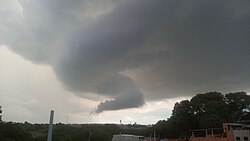
Image: Erik Kaue (stormchaser).
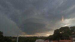
Image: Erik Kaue (stormchaser).
On the afternoon of Friday, June 27, 2025, a supercell thunderstorm developed over the city of Piracicaba, in São Paulo state, Brazil, attracting widespread attention due to an unusual tornado-shaped cloud formation. The storm began forming around 4 PM in Botucatu and evolved into a classic supercell as it moved over rural areas of the city.
Storm chasers documented the presence of a mesocyclone, a rotating air column fueling the storm, with strong updrafts. A striking funnel-shaped condensation appeared, but the chasers clarified this was not a tornado funnel cloud but a tail cloud, a low-level cloud feature caused by warm, humid inflow feeding the storm’s mesocyclone.
Following the event, the city experienced heavy rain and reports of small hail in several urban and rural areas, along with strong winds and significant hail accumulation in the countryside.
The Reporting Platform and Volunteer Network of Severe Storm Observers (PREVOTS) had forecast heightened instability for the region that day, warning that some storms might develop into supercells with hail as a main hazard.
Meteorologists of PREVOTS noted that the conditions leading to this rare winter supercell were due to the interaction between a cold, dry air mass, which caused temperatures to drop to 0°C (32°F) on June 25, according to the Integrated Center for Agrometeorological Information (CIIAGRO); and a warm front, coupled with moderate wind shear and high availability of warm, humid air, factors that are uncommon for this time of year.
Image: Windy.com.
![]()