
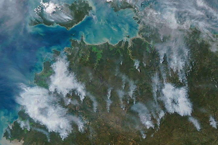
NASA satellites are detecting numerous fires across Australia’s Northern Territory, specifically in the Top End and Arnhem Land regions, during the typical May and June burning season. While some days, particularly in the afternoon, these fires can appear as large wildfires spreading over vast areas and generating significant smoke plumes in satellite imagery, closer inspection reveals a different pattern. NASA’s Aqua satellite captured images of smoke and fires on the afternoon of May 28, 2026. However, the fires burning in this region are generally smaller and less intense than they might initially appear. For instance, on mornings shortly before and after this date, NASA satellites detected minimal smoke despite observing many thermal anomalies, or hot spots.
The pattern, location, and timing of these fires are consistent with controlled burns intentionally ignited for land management purposes. Land managers typically start fires in the morning, with smoke accumulating throughout the day. This process can sometimes create large smoke clouds, as seen on May 28 and again on June 2, especially when updrafts and moderate winds carry the smoke away from the fires.
These fires primarily burn grasses, shrubs, and sparse trees adapted to the region’s tropical savanna ecosystem. Over the past few decades, land managers in the Northern Territory have combined established Indigenous land management practices with modern technologies to create large-scale land management programs. Projects like the West Arnhem Land Fire Abatement and Arnhem Land Fire Abatement aim to reduce more destructive and emission-intensive fires later in the dry season. They achieve this by intentionally burning some of the understory shrubs in the early dry season to create fire breaks and reduce fuel loads.
According to the Australian Bureau of Meteorology, the dry season typically commences in May and extends through September. Research indicates that these controlled burning efforts are showing signs of achieving their intended impact. Analysis of satellite fire observations suggests that controlled burning activities are shifting fire activity from the end of the dry season to its beginning, leading to a reduction in high-intensity fires and emissions.